Lily Style Author
Home | Ancestry scrapbook | Contact | Facebook
South Brent & Ivybridge’s forgotten fort
(first published in Ivybridge iMag in March 2023)
According to a 1794 survey, “Brent & Ivybridge” had barrack accommodation for a company of seventy soldiers. The survey had been commissioned a year after Britain went to war with Revolutionary France because there was a need to house a large number of troops within a day’s march of the naval base at Devonport.
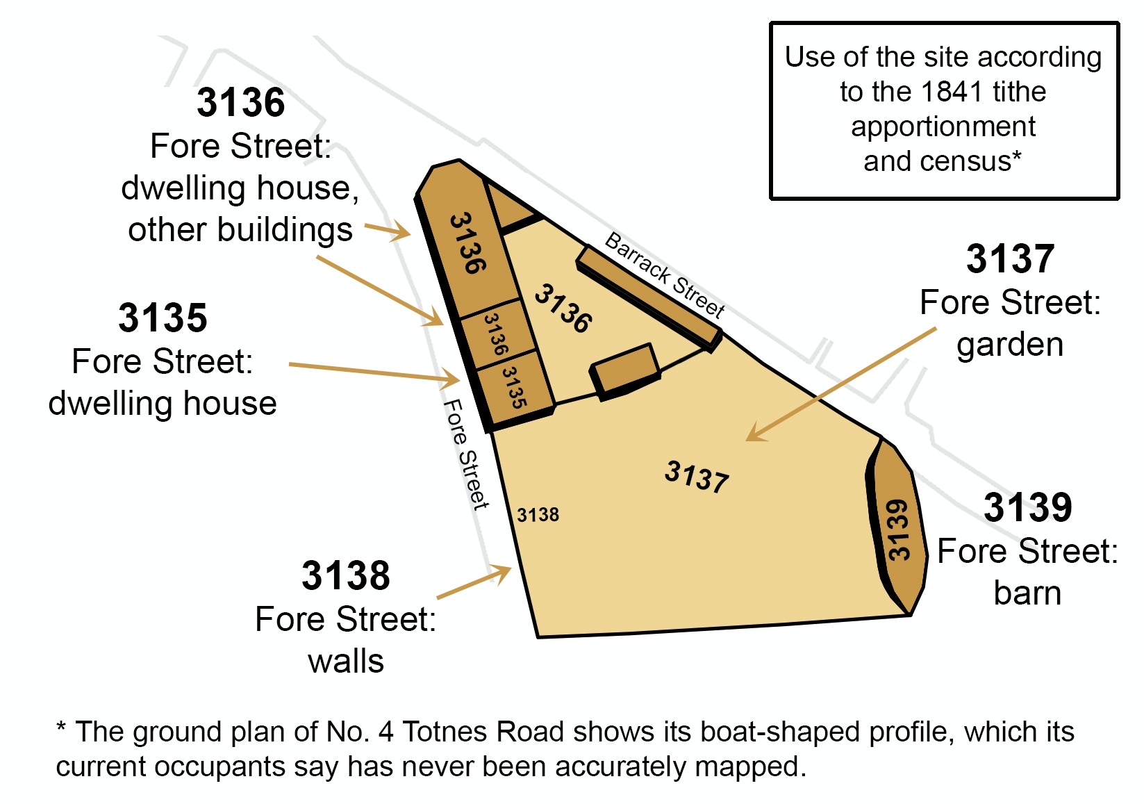
Where was this pre-1794 fort? There’s no hint of any military structure in Ivybridge before the 20th century. However, Heritage Gateway’s website says there’s a strong local tradition of a drill yard in South Brent “bounded by a solidly-built wall, mainly of granite river boulders, about 10-12 feet high, and by two blocks of buildings”. According to Heritage Gateway, a converted barn on the east end of the site and a block of residential buildings on the west “are of a curious character … and could be connected with the drill yard as stables and barracks respectively. What is now ‘Totnes Road’, is called ‘Barracks Road’ on the 1843 Tithe Apportionment.”
The site Heritage Gateway describes is a triangle of land between the junction of Totnes Road and Plymouth Road in central South Brent. Although few villagers realise it’s there, the fort’s perimeter walls seem pretty much intact. There’s even an arched gateway in the wall on Totnes Road, which looks like part of the original structure.
Rachel, the current occupier of Bowling House – on the northwest point of the triangle – says the attic used to be partitioned into cubicles, and there’s still a very grand fireplace on the attic’s far wall. An elderly neighbour told her Bowling House and the cottages next to it used to be connected by doors on both the first and second floors. The courtyard inside the site is made up of old cobbles. An outhouse marked on the 1840s tithe map is still there. It’s divided into three stalls and may have been stables. An arched gateway next to the outhouse is very similar to the one on Totnes Road.
Bowling House was done up in the 1920s or ‘30s, but an old photo postcard shows its north side built out of the same un-faced stone as the perimeter walls. Two doors are visible that are no longer there. The right-hand door is set into the corner of the building and has a substantial, masoned frame around it.
No records have come to light about the fort’s construction, but the last period of inland fort building before the 1793 Anglo-French war was during the reign of Charles II, more than a hundred years earlier. This was when the Citadel on Plymouth Hoe was erected. Local legend says the Citadel’s canons point towards the city instead of out to sea because its purpose was to keep Plymouth rebels at bay. Historical records confirm that the Citadel defended the Crown against anti-Royalist rebellion. Charles II (1660 –1685) was the first royal to rule England after Oliver Cromwell’s Puritan army seized power and chopped off the head of Charles I (the new king’s father). Although Parliament had voted to restore the monarchy after Oliver Cromwell’s death, not everyone welcomed the idea and forts were erected in anti-Royalist hotspots, like Plymouth.
Last month’s South Brent Archive article in iMag, “Puritan bullies in 1640s South Brent”, shows that the village had been an anti-Royalist stronghold.
We can’t know for certain when the fort was built without an archaeological investigation, but evidence points to the reign of Charles II in the late 1600s.
As a final note, readers may recall that South Brent Archive’s article in February’s iMag, “Dartmoor’s most haunted bridge?” included an account of a ghostly redcoat soldier sighted near the village. Perhaps the soldier had been stationed in South Brent & Ivybridge’s fort when he died?